
in FISH & SHIPS
Bibliothèque d’Archéologie Méditerranéenne et Africaine – 17
Production and commerce of salsamenta during Antiquity
éditions errance | Centre Camille Jullian
Introduction
The site of Tróia is located in the southwestern coast of Portugal on a sandy peninsula that separates the estuary of the Sado River from the Atlantic Ocean (fig. 1 and 2). In Roman times this sand spit was probably still a line of islands and the Roman settlement was possibly in the island of Achale referred in this area by Rufus Avienus in Ora Maritima (v. 182-184) 1.
It was certainly part of the territory of the civitas of Salacia (modern Alcácer do Sal) and the closest urban centre, c. 4 km away across the waters of Sado River, was the city of Caetobriga (modern Setúbal).
The heavy erosion the site suffers from the tides coming into the Sado estuary strongly contributed for its early discovery. Tróia appears in the literature since the 16th c. as a Roman settlement with fish-salting vats 2 and is frequently visited and referred by authors in the following centuries 3.
The first acknowledged excavations took place in the 18th c. by future Queen D. Maria I 4 and in the 1850’s an important series of excavation campaigns were carried on by Sociedade Archeologica Lusitana, from Setúbal.
The main results of these works were the discovery of habitation buildings and a bath complex. In the 20th c., from 1948 up to the 70’s, excavations were carried on by the directors of the today National Museum of Archaeology, exposing, in particular, several fish-salting factories, the bath complex, cemeteries and a Christian basilica.
A number of articles on specific aspects and materials resulting from these works were published, but only in 1994 was there a consistent presentation and interpretation of the industrial complex by R. Étienne, Y. Makaroun and F. Mayet 5.
In 2006 began a new project, promoted by troiaresort, for the conservation and presentation of the Roman ruins to the public. The necessary archaeological works, carried on by the authors, provided new information and an overall perception of the site that justifies this updated overview of the site of Tróia. It will focus in particular on the importance of the fish-salting facilities, the occupation rhythms and the nature of the settlement.
1. Referred by Alarcão 2004, p. 323.
2. Barreiros 1561; Resende 1593.
3. Castelo-Branco 1963.
4. Costa 1933, p. 19.
5. Étienne, Makaroun, Mayet 1994.
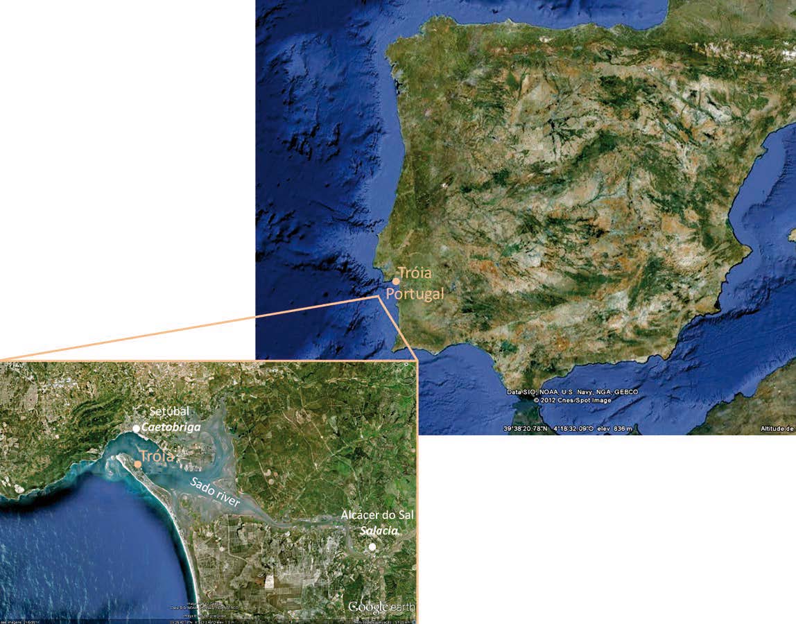
Fig. 1. Location of Tróia (www.googleearth.com)
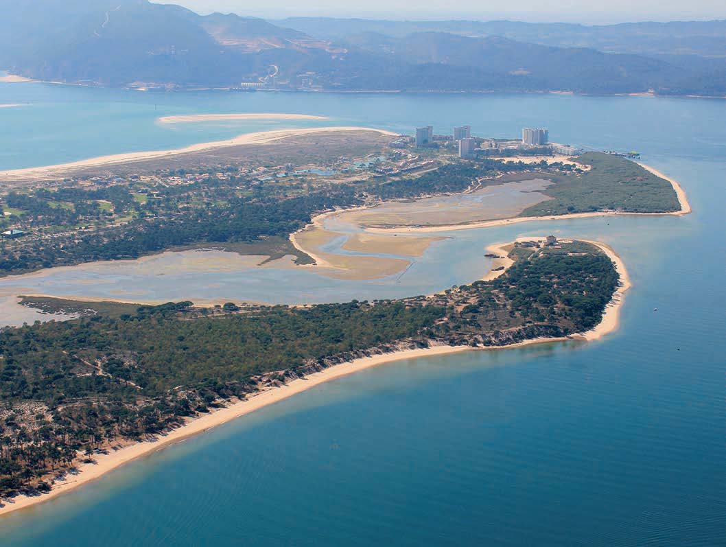
Fig. 2. Aerial photo of the northwest end of the peninsula of Tróia © Troiaresort.
1. A large fish-salting production centre
The environment of Tróia is highly favorable to fishsalting production. The shores of the Sado River have a long tradition of high quality salt exported in large quantities and its estuary and the surrounding ocean waters are extremely rich in fish up to this day providing an important fishing activity.
In 1987 J. Edmondson referred the site of Tróia as a vast fish-processing complex but only presented a rather late workshop resulting from the segmentation of a larger one 6. In 1994 R. Étienne, Y. Makaroun and F. Mayet documented the evolution of two large “factories”, presented also a small one and referred several others in the shore of the estuary demonstrating Tróia as the largest fish-salting production centre in the West 7.
A recent survey of the fish-salting facilities at Tróia 8, either uncovered by excavations or exposed by the tides, revealed twenty five “fish-salting workshops” or production units, that is, compartments with vats along the walls around a patio. Sometimes workshops were connected by a corridor (e.g. workshops 1 and 2 (fig. 3)) or in the same building (e. g. workshops 12 and 13 (fig. 4)) and it is assumed that they belonged to the same “factory”. But for most workshops it is impossible to know if they were autonomous or belonged to more complex facilities, or if distinct workshops had the same management. In the 3rd c. or later the large workshops were divided in smaller units not always easy to define and count.
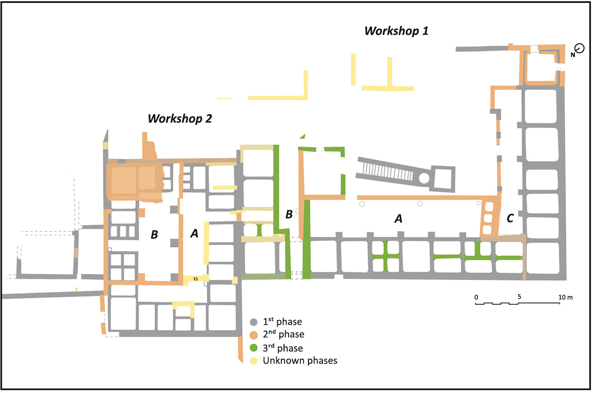
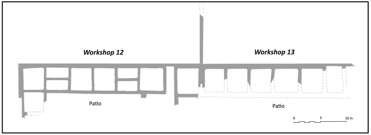
Fig. 4. Fish-salting factory with workshops 12 and 13 (1st – 2nd c.) (A. P. Magalhães based on J. L. Madeira (Pinto, Magalhães, Cabedal in press)).
Fig. 3. Fish-salting factory with workshops 1 and 2 in its three phases (A. P. Magalhães based on Étienne, Makaroun and Mayet, 1994, fig. 51 and J. L. Madeira (2008, unpublished).
The fish-salting workshops, located inland or more often next to the waterline, spread along the Sado estuary shoreline (fig. 5). They vary considerably in size but only three types have been recognized.
The most common type is a four-side vat workshop with a rectangular plan with lines of vats along the walls and around a proportionate patio. Some would be quite large, like workshops 1, 4, 12, 13 and 23 (fig. 6), and others smaller, like workshops 2 and 21 (fig. 7).
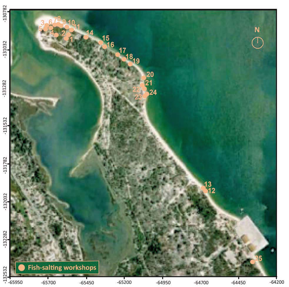
Fig. 5. Location of fish-salting workshops at the site of Tróia (A. P. Magalhães (www.googleearth.com)).

Fig. 6. Large four-side vat workshops with proportionate patios (A. P. Magalhães based on topographical survey by IPPAR (2006, unpublished)).
The second type is a U-shaped workshop with vats along three walls around a patio with the entrance in its longer side, like workshops 3, 5, 6 and possibly others rather incomplete like 10 (fig. 8).
The third type, with no complete example preserved, has two parallel lines of vats separated by a narrow patio or corridor and is probably also U-shaped, with a short line of vats in one top. There is no complete example but workshops 15, 17, 19 and 20 fit in this type and workshop 9 may be an example of its top (fig. 9).
Nine very incomplete workshops were not classifiable because they may fit in more than one type (fig. 10).
Since workshop 2 dates from the Tiberian period, and is the earliest building known at Tróia, we know the rectangular four-side vat workshop was built at Tróia since the beginning of the production centre. Workshop 1 was connected and therefore contemporaneous to workshop 2, and workshops 12 and 13 were abandoned in the 2nd c., meaning the larger and smaller version of the four-sided vat workshop were both common in the 1st-2nd c. All but 12 and 13 were divided in smaller workshops certainly in the 3rd c. for workshops 1 and 2, and probably at the same time for the others.
Even if no other workshop is dated, the three-side vat U-shaped workshop is also certainly from the 1st – 2nd c. since workshop 6 was divided in smaller units with a vat divided in a second moment, and was abandoned in the early or mid 4th c. Since we believe the workshops built at a low level, today in the waterline (workshops 3, 5-10,12-13, 15, 17-25) and most of them with large vats, are from the 1st – 2nd c., workshops 3 and 5 must be also from the first phase. In what concerns the third type, it includes another four workshops on the waterline, some of them were subdivided in a second moment (19 and 20) or with a vat subdivided (15) and therefore they must also belong to the first phase.
Only three workshops with very small vats located over sand dunes at higher levels (11, 14 and 16 (fig. 10), too incomplete to be classified in any type, are certainly late and may date to the 4th – 5th c.
Therefore the three types recognized are certainly from the 1st – 2nd c. Yet the four-side vat type may be slightly earlier at Tróia since workshops 1, 2 and 4 seem to occupy larger areas, but this is a mere hypothesis.
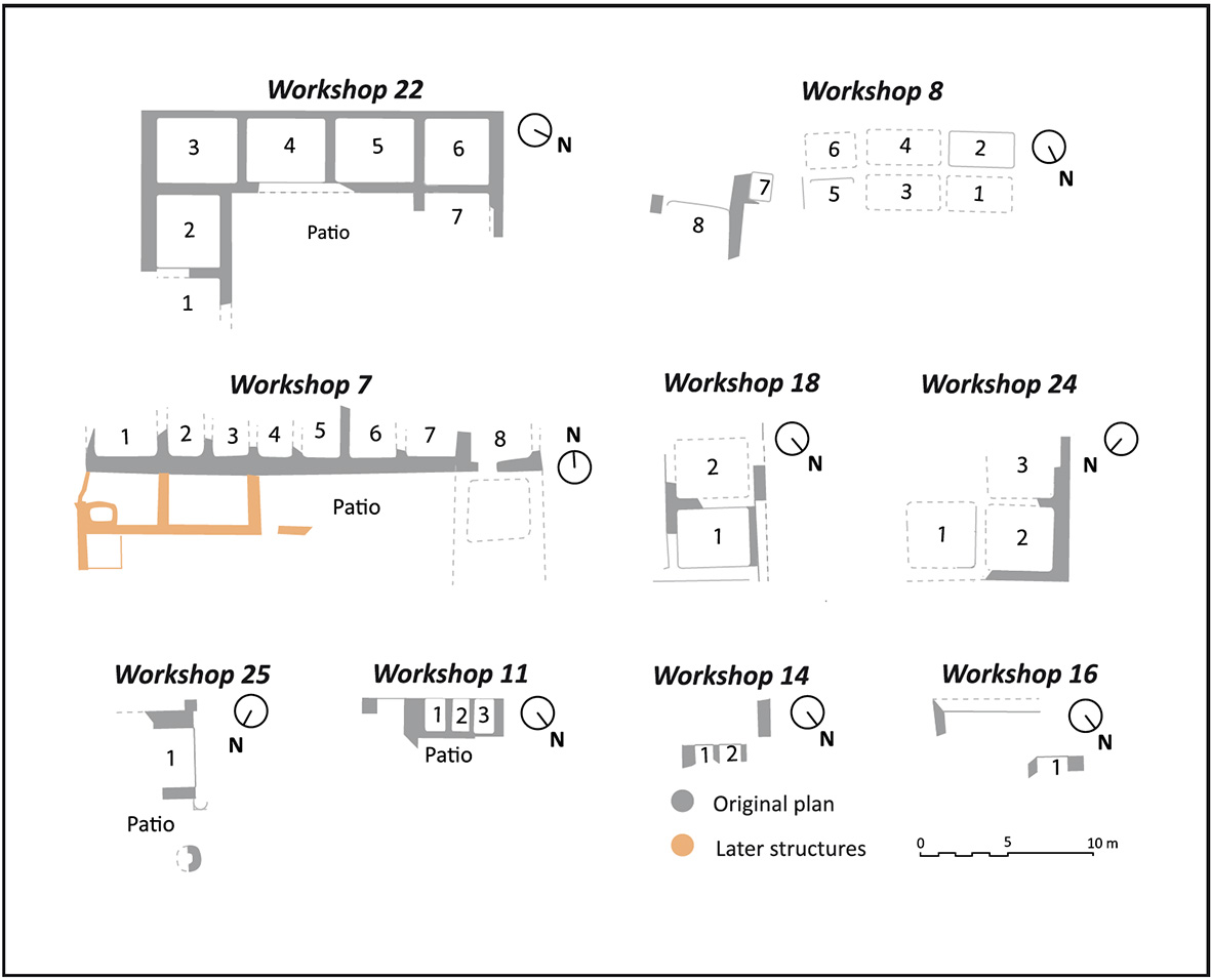
Fig. 10. Unclassifiable workshops (A. P. Magalhães based on topographical survey by IPPAR (2006, unpublished)).
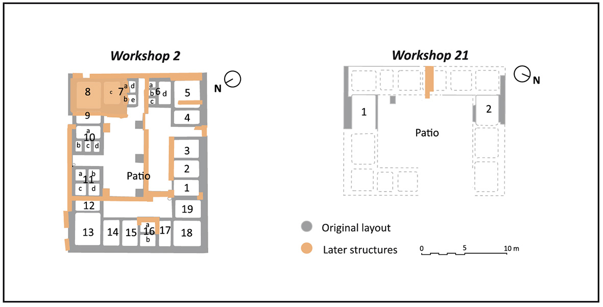
Fig. 7. Four side vat workshops with proportionate patios (A. P. Magalhães based on topographical survey by IPPAR (2006, unpublished), Étienne, Makaroun and Mayet, 1994, fig. 51 and J. L. Madeira (2008, unpublished)).
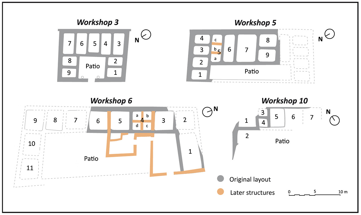
Fig. 8. Three-side vat U-shaped workshops with the entrance on the large side of the patio (A. P. Magalhães based on topographical survey by IPPAR (2006, unpublished)).
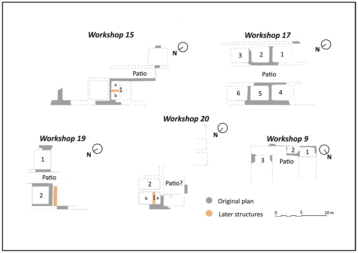
Fig. 9. Workshops formed by two lines of vats separated by a narrow patio or corridor, probably U-shaped (A. P. Magalhães based on topographical survey by IPPAR (2006, unpublished)).
Since all workshops except for the small 11, 14 and 16 are considered from the 1st – 2nd c., it means the fishsalting production centre of Tróia reached its highest production capacity in that period. Measuring the preserved vats (length, width and depth) from the original workshops and calculating their volumes results in a minimum production capacity of 1,429 m3 but only 80 of the 165 visible vats were measurable (fig. 11). With this production capacity Tróia surpasses the largest recognized western fish-salting production centre at Lixus, with a capacity of 1,013 m3 9. Since no larger centre was yet discovered in the Mediterranean, in the Black Sea or elsewhere, Tróia was certainly one of the largest fish-salting production centres of the Roman Empire in the 1st – 2nd c. AD.
This high production capacity at Tróia is due not only to the number of workshops but also to the large size of many of the vats. Twenty four measurable vats from six workshops (1, 4, 5, 6, 12 and 22) had a depth of 1.90 to 2.30 m and an inside volume between 20 m3 and 35 m3 while eight vats from five workshops had a volume over 35 m3 with similar depth. Two of these were exceptionally large: workshop 23 vat 1 (7.03 x 4.25 x 2.25 m) 10 had a capacity of 67.22 m3 and workshop 6 vat 1 (3.70 x 7.45 x 2.07 m) had a capacity of 57.06 m3.
Other workshops, on the other hand, had smaller ones, like workshop 2, whose largest vat was 1.38 m deep with a capacity of just 12.19 m3.
After the rupture of the late 2nd – early 3rd c., discussed in the following pages, some workshops were abandoned, many were subdivided and some had vats divided in smaller ones meaning a downsizing of Tróia’s production capacity.
Not knowing the moment of abandonment of many of the workshops on the shoreline, we prefer not risking a calculation of the general production capacity of Tróia after the 2nd c. for now. But the factory with workshops 1 and 2, the best studied even if not fully excavated, is an example of the effects of the economic retraction that affected Tróia after the 1st – 2nd c. production peak (fig. 12), even if the table presented only considers fully preserved vats and therefore excludes the non-excavated vats of workshop 1 and thirteen visible but not measurable vats of workshop 2.
According to these numbers, workshops 1 and 2 together suffered a reduction in their volume of 1/8 of their initial capacity, but workshop 2a managed, in the third phase, to triplicate its capacity, suggesting economic growth in the 4th c.
Other areas were more affected. The abandonment of workshops 12 and 13, some of the peripheral workshops, after the 2nd c., may indicate a shrinking of the occupation area. And the inactivation of workshop 6 in the first half of the 4th c. suggests a more drastic production reduction that was not at all compensated by the very small new workshops 11, 14 and 16.
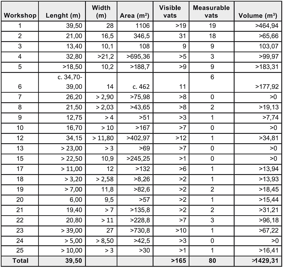
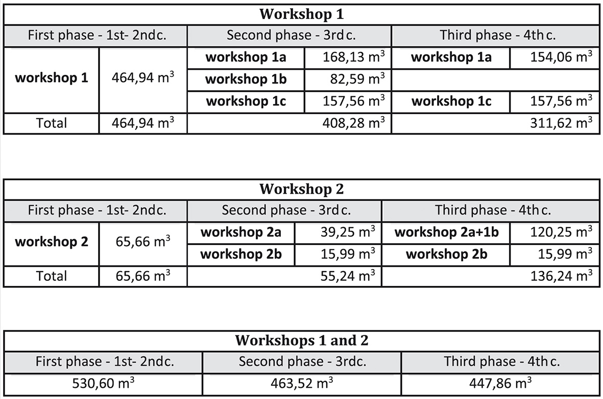
Fig. 12. Production capacity of workshops 1 and 2 in their three phases.
Fig. 11. Area, number of vats and production capacity of the workshops considered from the 1st – 2nd c.
2. The rhythms of occupation
The consistent study and interpretation by R. Étienne, Y. Makaroun and F. Mayet of the fish-salting factories uncovered at Tróia revealed three phases of occupation, the first one in the 1st – 2nd c., the second corresponding to the 3rd c. – early 4th and the third to the 4th and 5th c. 11
The research developed by the authors from 2007 to the present confirmed these conclusions bringing more evidence, more detail and sometimes more precision to the dating.
2.1. The first phase (1st – 2nd c.)
New data concerning the beginning and the end of the first phase of occupation of the large factory of workshops 1 and 2 resulted from works in workshop 2 and in the storeroom area next to it.
An excavation in this area, next to the northeast wall of workshop 2 (fig. 13), exposed stratigraphic units with Italic type terra sigillata Consp. 22 and 25.1, one fragment of the South Gaulish terra sigillata cup form Drag. 27, Italic and Baetican Dressel 2-4 and regional Dressel 14 var. A amphorae that point to a date in the Tiberian period. They date the construction of workshop 2 and since these are the earliest levels ever detected in Tróia, they also date the founding of the production centre at Tróia for now 12.
That also means Tróia is the earliest fish-salting centre so far known in the low valley of the Sado river but contemporaneous to amphora kilns in Largo da Misericórdia (Setúbal) 13 and Abul (Alcácer do Sal) 14, located on the other shore of the river where clay was abundant. These kilns would provide Tróia, always dependent on amphorae made on the other shore.
The large number of workshops believed to have been built and active during this phase suggests great economic activity. The only change detected in the course of this period is the digging and building of the well located in the patio of workshop 1 15. A trench opened for conservation purposes along the wall of the staircase of that well revealed a stratigraphy with three successive floors (fig. 14). The earliest one (unit [738]) covered the layers related to the construction of the well with a number of ceramics from the 1st – 2nd c. with several fragments of Gaulish terra sigillata with marks, but also 2nd c. amphorae, the regional Dressel 14 var. C and Dressel 20 from Hadrian’s period, meaning the well was most probably built in the first half of the 2nd c.
It accounts for the progressive investment in this large workshop along this phase.
10. Étienne, Makaroun, Mayet 1994, p. 99.
11. Étienne, Makaroun, Mayet 1994.
12. Pinto, Magalhães, Brum 2011, p. 135-138.
13. Silva 1996.
14. Mayet, Silva 2002.
15. Pinto, Magalhães, Brum 2010.
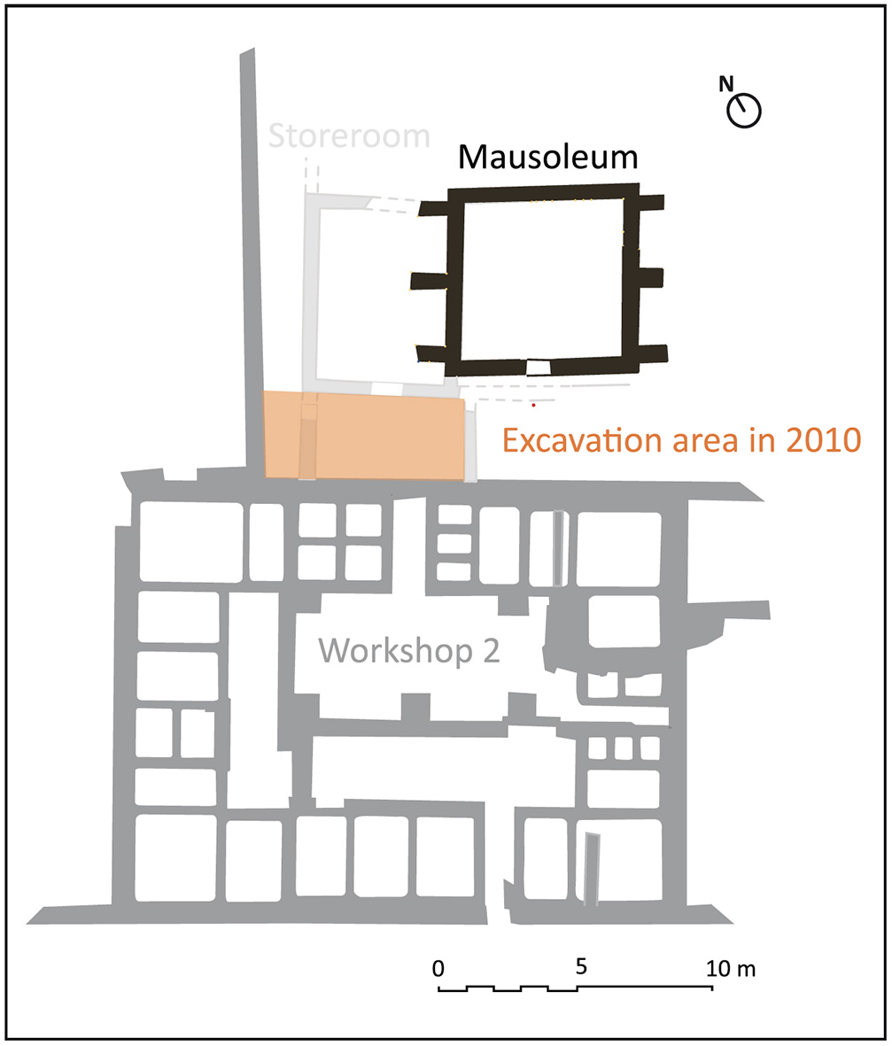
Fig. 13. Location of excavation area next to workshop 2 (A. P. Magalhães based on Étienne, Makaroun and Mayet, 1994, fig. 51 and J. L. Madeira (2008, unpublished)).
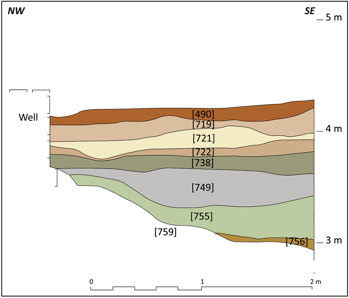
Fig. 14. Northeast section in the sounding next to the well of workshop 1 (A. P. Magalhães).
Based on the filling of workshop 1 vats 1 and 15, R. Étienne, Y. Makaroun and F. Mayet inferred, at the end of the first phase, a period of abandonment in the late 2nd c. before destruction 16. This abandonment also happened in workshop 2 where vats 6, 8 and 9 were excavated in 2007 to reveal that they only served in the first phase of occupation, having been abandoned in the second half of the 2nd c.17. They were clean from fish remains and their deposits contained Hispanic terra sigillata (Drag. 27, Drag. 37, And. 1), African Red Slip type A (Hayes 9B), amphorae Dressel 14 and Late Dressel 14 (Dressel 14 Tardia) among other things. Moreover, vat 9 revealed wall lining fragments fallen over the broken pottery in the bottom of the vat confirming a period of abandonment before reuse.
In contrast to workshop 1, those vats did not hold any signs of destruction from collapsing walls or roof, the refuse deposits and wall lining in vats 8 and 9 having been covered by a sand filling destined to support pavements on top belonging to the second phase.
The southeast workshops 12 and 13 (fig. 4), certainly belonging to one sole “factory”, were studied in 2007 18.
It was clear these workshops and the surrounding area were only occupied in the 1st – 2nd c. and abandoned at some imprecise moment of the 2nd c. Vat 3 of workshop 12 was excavated to reveal no signs of fish remains or refuse, just a layer of fallen roof tiles and clay with rare fragments of ceramics, two of them of Dressel 14 amphora. Apparently the area was abandoned not long after the vat was emptied from its last production since the roof material fell on an empty pavement and the collapse seems to have been due to its decay and not to any sudden event.
The absence of refuse on the floor of the vat and of any ceramics after the 2nd c. in the courtyard behind the workshop suggests the area was abandoned when the factory became inactive.
Was the abandonment due to the same causes as in workshops 1 and 2 or was it due to others reasons, like an early advance of the waters, since nowadays more than three quarters of these workshops have been taken away by the tides?
The fact is that in the excavated 1st – 2nd c. vats in three workshops there were no remains of the last production, the vats having been carefully cleaned. Did it mean, as F. Mayet and C. Tavares da Silva have pointed out, that the vats were ready for the next production? 19 Was there a non previewed interruption of the usual seasonal labor? Planned or not, what caused this interruption? There is no satisfying answer.
It is clear that it was not a local event, since the rupture after the late 2nd c. is well known as the 3rd c. crisis and was a reality in the Southwest of Hispania and in the Northwest of Morocco as F. Mayet and C. Tavares da Silva have documented 20. These authors claim that only a major natural catastrophe may explain such a general destruction and abandonment at the same moment. An earthquake followed by a tsunami would have destroyed everything in the shoreline, like salt marshes, fish-salting factories, fishing boats and amphora kilns, causing a long lasting negative effect on the economy of these regions 21.
At Baelo Claudia, in the near province of Baetica, the works of the University of Cadiz revealed clear evidence of abandonment in the late 2nd c. in several areas including a building in the industrial quarter where it was very obvious the collapse of the walls only happened over a thick filling of refuse 22. Moreover, multiple evidence point to a possible “general abandonment” or of good part of the insulae of the barrio meridional that includes the industrial quarter. This abandonment was not due to any violent episode or fire, and fishing and fish-salting activities kept going since the abandonment levels were rich in residues of these activities 23. The real cause is not known.
Neither at Tróia did the archaeological record give the answer so far. There is no evidence, at the end of the first phase, of a major sudden destruction of the buildings just as at Baelo Claudia. But while at Baelo the industry kept going for a while, at Tróia the abandonment is testified by the inactive vats. And the effective interruption of the production was recently confirmed by a tomb built in the patio of workshop 1, next to the well, and violated and refilled in the second quarter of the 3rd c. 24
2.2. The second phase (3rd – early 4th c.)
The socio-economic changes in the 3rd c. are more than evident at Tróia at different levels. The large fishsalting workshops appear divided in smaller ones; there is a radical change in the amphorae with a diversification of their shapes; and even the funerary practices change with the introduction of inhumation in the late 2nd c.
The recent works have brought some evidence on the dating of the beginning of the second phase in workshops 1 and 2.
Workshop 2 was divided in two smaller workshops and one of them, workshop 2B, was covered by a new pavement with a layer of pottery fragments. Among many fragments on the surface, only regional Dressel 14 and Baetican Almagro 50 amphorae were detected.
The presence of this last amphora and the absence of Almagro 51c var. B, omnipresent by mid 3rd c., points to a date between the late 2nd c. and the second quarter of the 3rd c. In a second moment, vat 8 was filled with sand and covered by a pavement that had one fragment of African Red Slip type C Hayes 50 indicating a date not earlier than the second quarter of the 3rd c. These construction moments are not dated with precision, but since the vat had refuse in the bottom, we presume that only a short period ran between the construction of the new pavement of the patio and the remodeling of that vat into a compartment.
In workshop 1 the only datable evidence is the clay floor that covered the above mentioned tomb in the patio next to the well. We proposed to date this floor to the second quarter of the 3rd c. due to the abundant 2nd c. and some 3rd c. ceramics it contained, the latest being African Red Slip type C and amphorae Almagro 51c, var. B 25.
Since this floor was built after a period of abandonment, confirmed by the tomb, we believe it is the new floor resulting from the remodeling of the workshop when it was divided in several smaller units, leaving the well in a central yard.
Therefore both workshops 1 and 2 may have restarted the production in the first half of the 3rd c. but workshop 2B at an earlier moment than the others.
According to R. Étienne, Y. Makaroun and F. Mayet, the new workshop 1B resulting from the division of workshop 1 was attached to workshop 2 still undivided 26. The evidence and interpretation just presented point to the division of this workshop probably in the first quarter of the 3rd c. and we believe workshop 2A was not connected to workshop 1B during this phase since there are signs of the entranceway between the two having been blocked and later on reopened (in the third phase). Workshop 1B would then be autonomous with its patio with access to the well as the other production units of workshop 1.
The above mentioned workshops subdivided possibly in the 3rd c. (workshops 6 and 21) suggest the activity restarted in different areas of the settlement reusing the old workshops but on a slightly reduced scale.
This phase lasted until there were cases of abandonment and remodeling in the first half of the 4th c., but the break between the second and the third phase is not well defined and different areas had different developments and possibly timings.
The one example of abandonment is workshop 6 vat 3 whose bottom was excavated before it was recovered by a beach refilling 27. The vat was partially destroyed and regularly flooded by the tides, but surprisingly the lowest units of its filling were preserved in the southwest part, including a layer of fish products remains (fig. 15).
This last unit [1307] just had rims of African Red Slip type C Hayes 50 var. A and amphora African II C pointing to a dating in the late 3rd c. – first half of the 4th, but possibly not later than the early 4th c.
Even if this workshop was divided in smaller ones, the abandonment could probably extend to the whole productive unit, since its southwest part was reused as a cemetery and later built over by a Christian basilica. It is the only documented case, so far, of a vat or workshop abandoned in the first half of the 4th c.
Fig. 15. Aspect of the excavation of the fish products remains layer in workshop 6 vat 3 ((I. V. Pinto).
21. Id., p. 128-129.
22. Bernal et al. 2007, p. 383-389.
23. Id., p. 452.
24. Pinto, Magalhães, Brum 2010, p. 140-141 and figs. 6, 8-9.
25. Id, p. 139-140.
26. Étienne, Makaroun, Mayet 1994, p. 84-85 and fig. 56.
2.3. The third phase (4th-5th c.)
The third phase was inferred by R. Étienne, Y. Makaroun and F. Mayet from the walls built over vat 15 later than the first wall subdividing workshop 1. The northeast line of vats was then definitely separated from the rest of the workshop by a wall over its southwest limit and connected to workshop 2A 28.
Workshop 2A had the entranceway to workshop 1 reopened and considerably augmented its production capacity by acquiring at least four new vats (workshop 1 vats 16-19), three of them very large.
Workshop 2 did not give any dating element to this enlargement neither did workshop 1 for the second walls over vat 15. R. Étienne, Y. Makaroun and F. Mayet suggested the first half of the 4th c. but could not confirm it.
The recent works next to the well of this workshop revealed a second floor [721], this one paved with mortar and not well preserved (fig. 14). It contained African Red Slip type C (Hayes 58A and 50A/B) and a few fragments of type D (Hayes 58), regional amphorae Almagro 51c, var. B and Keay 78/Sado 1, Baetican amphorae Almagro 50 and 51c and some African amphorae, probably Tripolitania III and African II or III, datable from the end of the 3rd c. to the mid 4th c. 29 This is the evidence of works having been done in workshop 1 in the first half of the 4th c. even if it is not possible to physically connect them with the new dividing walls in the northeast area.
Other areas of Tróia showed changes in the first half of the 4th c. Part of workshop 6, as mentioned above, was turned into a funerary precinct and so was the probable house southwest of this workshop whose last wall paintings were dated to the end of the 3rd c., early 4th. 30 A sounding in workshop 6 vat 8 revealed that before the pavement of the basilica was built, this vat had been reused as a collective sepulchre with several tombs and sealed with a cover of opus signinum. Under the cover there was a Keay 78/Sado 1, var. B amphora rim not earlier than the mid 4th c. Therefore the cemetery may have been installed in the 4th c., after the production ceased in this workshop.
But if the downsizing of the fish-salting facilities is evident in the 3rd and 4th c. with productive units giving place to other uses, the production continued in other workshops and workshop 2A triplicates its production facilities in the late 3rd or first half of the 4th c.
This last phase of fish-salting production ends in the first half of the 5th c. The best evidence is the filling of the abandoned vats and the layers that covered the whole area of workshops 1 and 2 documented both by old and recent excavations.
One of the authors (APM) recently studied the terra sigillata and African Red Slip from workshop 1 from old excavations (1956-1961) and a 2008/2009 excavation of an area southeast of the well 31. The pottery came essentially from garbage dumps accumulated in the vats and in the large patio of workshop 1. Their study revealed significant imports of African Red Slip type D (Hayes 59, 61, 67, 80, 91 being the most abundant) with a peak in the late 4th – early 5th c. pointing to an abandonment of the production in the second quarter of the 5th c. The study of the amphorae comforts this chronology with the predominance of Almagro 51c var. C over other types and some rare examples of 5th c. imported amphorae like Keay XXXV B and Late Roman 1a 32.
Vats 1 and 5 and vat 7c in workshop 2 33 had pointed to a mid 5th c. dating based mainly on the presence of Hayes 80A in African Red Slip type D. Since their set of forms is similar to that recently studied, those levels should also be assigned to the second quarter of the 5th c., including form Hayes 80A.
2.4. Later phases
Vat 19 and vats 1 and 5 in workshop 2, certainly as others excavated in the past, were left with the fish remains from the last production and were then filled with refuse and later with wall debris. It is clear people stopped producing not bothering to clean the vats, but did not abandon the area for a certain time. In workshop 2 a number of late small walls, some forming small compartments and the removal of vat 7c 3rd c. floor 34 suggest this workshop was still in use for other purposes.
In a second moment tombs were built in the area, at different levels, some on the floor of the patio of workshop 2, one inside workshop 1 vat 16 and many were excavated in the debris layers.
In the northwest area of workshop 2, untouched, it was possible to register the destruction layers of the workshop. In the southwest area units of roof and wall collapse were interposed by sand layers that suggest decay over a rather long period of time with collapsing episodes followed by accumulations of windblown sand.
There is a severe decline since the midst of the 5th c. 35 but the latest imported fine ware, though quite rare, lasts through the 6th c. 36 meaning other unexcavated areas may have had a longer occupation. The site was abandoned to be covered by sand dunes. A popular quatrain tells Tróia was razzed to the ground by a “sand rain”.
27. Silveira et al. in press.
28. Étienne, Makaroun, Mayet 1994, p. 88.
29. Pinto, Magalhães, Brum 2010, p. 139.
30. Maciel 1996, p. 235-238.
31. Silva 2010.
32. Pinto, Magalhães, Brum 2012.
33. Id., p. 529.
34. Id., p. 534-537.
35. Silva 2010, p. 112.
36. Étienne, Makaroun, Mayet 1994, p. 43-49.
37. Alarcão 2011, p. 326-327.
3. An industrial quarter, a vicus or a city ?
The Roman remains at Tróia spread along 1.5 km in the shoreline but the deep sand dunes and the pine forest difficult the definition of the proper limits of the site. Yet the two southeastern factories (workshops 12-13 and 25, fig. 5) seem rather isolated and were certainly peripheral.
Those southeast of workshop 15 to workshop 24 are implanted in a nearly continuous line of constructions but it is not clear if the area to southwest was also urbanized. It is the area from workshop 15 to northwest that would be densely constructed even if a large part hasn’t been excavated. This area represents approximately 4 hectares but it originally extended further to the northeast, this part having been taken away by the tides.
There is no doubt that it was a large settlement.
Since Roman Tróia has not yet been identified with any of the settlements referred by classic texts, only with Avienus’s island of Achale, the question is if it ever became a real city or if it was an industrial vicus or simply an industrial quarter.
Referring only the most recent interpretations, J. Alarcão presented Tróia as a secondary urban agglomerate or a vicus, possibly the Caepiana of Ptolemy 37.
J. Soares and C. Tavares da Silva, on the other hand, referred Tróia as the main industrial quarter of the city of Caetobriga, its location on an island reinforcing its dependence on the urban agglomerate on the other shore 38.
It is obvious that Roman Tróia had some town planning since buildings generally have the same alignment northeast-southwest with small variations, and a proposal of the cadastre plan of Tróia was presented by Jorge de Alarcão in 2011 39. An essay to draw, in the top plan of Tróia, the visible pathways bordering and separating several workshops and other buildings brought unexpected results. Prolonging those bordering workshop 4 to northeast revealed they were perfectly aligned with the narrow paths that separate workshops 8 from 9 and workshop 10 from a building to northwest, forming a long rectangular lot. Since workshop 4 is c. 33 m wide, this lot would be c. 35 m wide, this measure coinciding with one actus, the basic unit of Roman agrimensura (120 Roman feet equal to 35.52 m). Since the factory with workshops 1 and 2 seemed to fit into a similar long narrow lot, a grid of one actus wide lots was applied to the supposed “urban” area of Tróia (fig. 16). In fact, that factory fits roughly in one of those lots. Only the southeastern part of the baths, considered from the 3th c., is on the next lot, and a second phase wall prolonging workshop 2’s southwestern wall invades the lot to northwest.
The buildings of the residential quarter exceed the northwest limit of another supposed lot but they do not belong to the first construction phase as J. Alarcão has pointed 40. At the northwest end of the urban area, including workshops 3, 5, 6, 7 and 8, the orientation of buildings and streets is irregular and more chaotic. It was probably originally a peripheral area where the buildings and the street grid adjusted to the shoreline. The southeastern workshops 20 to 24 do not seem to be implanted on a regular grid either. This cadastre plan coincides roughly with that proposed by Jorge de Alarcão even if we are not able to propose perpendicular axes.
It is quite evident there was a delimitation of the land consisting on a cadastre plan of rectangular equidistant lots one actus wide even if it is not obvious how far southeast that went.
This cadastre plan is not that of a city (colonia or municipium) since there is no cardus or decumanus nor real streets, only narrow sand paths between buildings, sometimes as narrow as 1.20 m and not wider than 1.80 m. The paths dividing the lots seem also too narrow for a vicus. It is also certain these lots were not for cultivation for the white sand soil of Tróia was not suitable for agriculture.
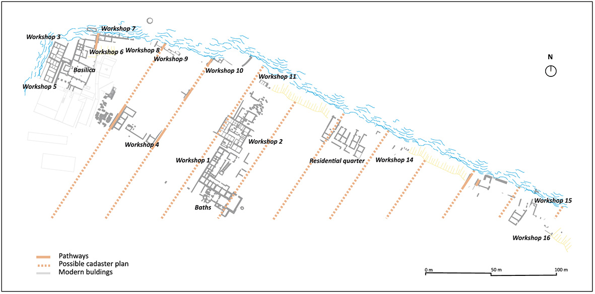
Fig. 16. Possible cadastre plan of Tróia (A. P. Magalhães based on topographical survey by IPPAR (2006, unpublished)).
Looking at the buildings exposed at Tróia, the omnipresent fish-salting factories stand out by their number and some by their size, and they are scattered through the whole excavated area. Apparently the reason to occupy the sandy land of Tróia was to install a large fish-salting production centre since the size of the lots seems adjusted to that purpose and factories seem to have occupied the largest part of the lots. Its location at the mouth of the river next to the ocean, on a flat area of easy access, was convenient for fishermen to deliver their catch and for trade boats to fetch their cargoes. Salt-marshes and pottery workshops would deliver by boat, from shore to shore, the salt and the amphorae.
Either Salacia, the civitas capital, or Caetobriga, across the river, could have taken the initiative to prepare the land of Tróia for the installation of fish-salting factories. Did Caetobriga install an industrial quarter 4 km away to protect itself from the nasty smell of the fish sauces preparation ? Since Caetobriga has the same strategic position as Tróia, and its own fish-salting factories, it seems possible that Salacia, upriver, would install an industrial centre at the mouth of the river. The homage referred in an incomplete inscription to L. Cornelius Bocchus, provincial flaminius, military tribune of the III Legio Augusta 41 and member of an important family from that city, may recall the intervention of Salacia in its beginnings.
Even if it started as an industrial quarter, the development of the fish-salting business brought economic prosperity and trade connections that gave Tróia a reasonable autonomy. It remained dependent on building materials and foodstuffs and the tights with Caetobriga, the nearest city, were certainly very strong. But the wealthy residences with wall paintings and mosaics, the Mithraic and Christian temples, the cemeteries with funerary epigraphy, the abundant imports in terra sigillata and amphorae as the quality of metal and bone objects are signs of the dwelling of rich as well as common people, slaves, freedman and foreigners. They point to a very lively and dynamic urban agglomerate whose name will hopefully be revealed in the future.
38. Soares, Silva 2012, p. 63-65.
39. Alarcão 2011, p. 337.
40. Id., p. 337.
41. CIL II 5180; Encarnação 1984, p. 276. V. also Diogo, Trindade 1999 and Morais 2007
Conclusion
The twenty five fish-salting workshops identified at Tróia make this production centre one of the largest in the Roman world from the 1st to the 5th c. AD. The evidence points to the planned occupation of the sandy soil of Tróia with the purpose of installing an industrial complex with fish-salting factories. Recent works have confirmed the rhythms of occupation proposed by the first studies and confirm a period of great prosperity in the 1st-2nd c. followed by an unexplained temporary abandonment in the second half of the 2nd c. The fishsalting activities restarted apparently in the beginning of the 3rd c. reusing the old factories but the production capacity was reduced by the division of workshops and vats and the abandonment of some production units. The beginning of the 4th c. must have been another moment of change with the abandonment of one large workshop, or part of it, and the reorganization of others. Active at least up to the middle of the 5th c., Tróia was definitely a very productive pole of the large fish-salting centre of the low Sado valley.
Customer Care
O CAN THE CAN utiliza cookies para lhe proporcionar uma melhor experiência online. Ao continuar a sua visita ao nosso site, concorda com a utilização de cookies.
Contact
reservations@canthecan.net
info@canthecan.net
T. +351 914 007 100
T. +351 218 851 392
Terreiro do Paço 82/83
1100-148 Lisboa – Portugal
Open everyday from 9:00 AM to 1:00 AM