

ABSTRACT
Initiated by Augustus, Rome’s Atlantic policy seems to have been consolidated in the age of Claudius, with the acknowledgement of the economic potential offered by the Atlantic region. It is in this context that we must understand the development of the salted-fish industry in Lusitania. In the same geographical contexts, and in close relationship with fish-processing factories, are known about 20 pottery centres producing amphorae, located in the regions of Peniche, Sado and Tejo valleys, and the coasts of Alentejo and Algarve. This production extended in time beyond the end of the Western Roman Empire and up to the end of the 5th and 6th centuries, according to the archaeological data of some amphora kilns and fish-processing sites. The identification of Lusitanian amphorae in distant consuming centres and several shipwrecks in the Mediterranean basin confirm the long-distance commerce and the total integration of this “peripheral” region into the trade routes of the Roman Empire.
The inclusion of the Lusitania Province and the northwestern Iberian Peninsula into the Roman Empire allowed for the existence of regular long-distance contacts with other provinces and especially with the Mediterranean. The spreading out of Rome’s power to Britannia and Germania Inferior – a process completed in the middle of the 1st century AD – inevitably provided the Roman Empire with a wide Atlantic coastal area.
The trade networks established along the Atlantic facades of the Iberian Peninsula supplied not only the cities but also, and above all, the fixed military camps located in the northwestern Iberian Peninsula. The archaeological data suggests a preferred relationship with the Baetica province and the port of Gades, where the supply of corn, wine and olive oil was controlled by the state (Remensal Rodriguéz 1986, 111; Morillo Cerdán and Salido Domínguez 2010, 148). Those military supply networks can also be related to the more recently established routes towards Britannia and Germania Inferior (Fernández Ochoa and Morillo Cerdán 2010, 115; García Vargas 2010, 65).
Actually, despite some sailing difficulties, the Atlantic route constituted the best choice considering the distance/cost relationship (Carreras Monfort 2000; Blot, M.L. 2003; Fabião 2009a, 53). However, international studies have valued the importance of the Gallic isthmus and the Rhone and Rhine routes, underlining the supposed Hispanic peripheral condition and depreciating the Atlantic route (Carreras Monfort 2000, Fabião 2009 a).
The lack of shipwreck records on the Atlantic coast from Cadiz to La Coruna in the work of Parker (1992), coupled with a somewhat non-contextualised analysis of Ora Maritima (ca. 4th century), has contributed to an increased skepticism regarding the Atlantic navigation of the Romans. Cadiz, described by Strabo (ca. 1st century) with enthusiasm, lay in ruins three centuries later, according to Avienus (Mantas 2000).
Nevertheless, in the last decades, archaeological underwater discoveries in maritime and fluvial contexts (Bombico 2012, Cardoso 2013, Blot and Bombico 2014) along the Atlantic facade have contributed to a better understanding and characterisation of settlements and sea routes.
Initiated by Augustus, Rome’s Atlantic policy seems to have been consolidated in the age of Claudius, with the acknowledgement of the economic potential offered by the Atlantic region (Mantas 2002–2003, 459; Fabião 2005, 84). In fact, between the middle of the 1st century BC and the 1st century AD, the quantity of archaeological evidence
indicative of Roman presence in the western Iberian Peninsula grows exponentially, confirming data found in classical literature sources (Pomponius Mela, Pliny, Strabo and Avienus). Thus, Pliny wrote that “the cities worthy of mention on the coast, beginning from the Tagus, are that of Olisipo, famous for its mares, which conceive from the west wind; Salacia, which is surnamed the Imperial City; Merobriga; and then the Sacred Promontory, with the other known by the name of Cuneus, and the towns of Ossonoba, Balsa, and Myrtili”.1
1 Cf. Pliny, Nat. Hist., 435.21.
The complexity of the Atlantic environment makes it particularly difficult to recognise ancient port facilities and calls for a reflection on the concept of harbour space. In fact, these vestiges are not always materialized in specific harbour equipment. Sometimes, it could be that, as described by Strabo regarding the Tiber River, ships were unloaded through the use of smaller vessels (Blot, M.L. 2003, 22).
The historical and archaeological data collected in the last decades suggest the following scenario:
– the existence of a significant exploitation of marine resources (mainly fish products) correlated with amphora kilns;
– an interest for estuaries and the influence they had on the development of Lusitania’s maritime cities;
– the proliferation of archaeological records related to transport and circulation of goods by sea along the Atlantic coastline (such as the pattern of distribution of some amphorae and terra sigillata); and lastly,
– the identification of archaeological remains of ancient navigation (lead anchor stocks, shipwrecks and lighthouses).
The main Roman viae in Lusitania seem to arise, on the one hand, from the necessity to link maritime cities among each other, and, on the other hand, from the necessity to connect them to the fluvial routes that penetrated the territory (Mantas 2002–2003). This means that roads combined maritime routes and oceanic termini with inner termini (Blot, M.L. 2003). These elements suggest an ancient economy based on both agriculture and fishing to which sea trade was added. The development of salt exploitation, linked to fishing activities, allowed for the production of salted fish, one of the most important industries in Roman Lusitania (Edmondson 1987, Fabião 2009b).
Jaime Cortesão was the first Portuguese author to suggest the existence of an “Atlantic settlement process” in Roman times (Fabião 2009a). Later studies have further analysed that topic (Edmondson 1987, Mantas 1990, Blot, M.L. 2003). It is interesting to note that the cases of the Sado and the Tagus rivers seem to confirm Jaime Cortesão’s supposition and, indeed, there are indications of coastal settlement (or coastal settlement increase) in Roman times (Fabião 2009a). It is in this context that we must understand the development of the fish products industry in Lusitania.
The ancient Lusitanian maritime installations were made up by a set of harbours, the so-called “harbour complexes” (Blot, M.L. 1998, 154; Mantas 2000; Blot, M.L. 2003), integrated into the same navigable geographical reality, such as an estuary. In the same geographical contexts, and in close relationship with fish-processing factories, are known at least 18 pottery centres producing amphorae, located in the regions of Peniche, Sado and Tejo valleys, and the coasts of Alentejo and Algarve (Mayet 2001, Fabião 2004). In perfect geographic relationship with the kilns, and dependent on fishing and the extraction of salt, were developed the fish-salting workshops (Fabião 2009b) (Figures 1 and 2).
Although the classical authors do not mention this kind of production in Lusitania, the importance of the salted fish industry is evident given the extensive structural remains of cetariae distributed along the southern and western coasts of the province, indicating a significant production volume (Fabião and Guerra 1993, 999; Étienne and Mayet 1993–94, 218). Moreover, with 25 identified fish-salting workshops, Tróia was one of the largest production centres in the Roman world (Vaz Pinto, Magalhães and Brum 2014, 156).
The oldest evidence of a fish products industry and its containers dates from the beginnings of the Principate and is generally associated with ovoid amphorae from the Julio-Claudian period, particularly with the workshops of Abul and Pinheiro (Sado valley), and Morraçal da Ajuda (Peniche) (Fabião 2004, Fabião and Morais 2007, Fabião 2008).
Between the middle of the 1st and the end of the 2nd centuries AD the Dressel 14 amphora dominated the production in Lusitanian kilns. During the 2nd century begins the production of a new type of amphora in the pottery centres of Sado and Tagus, the Lusitana 3. This type, characterised by its flat bottom that seems to be inspired by the Gauloise 4 type, has been typically associated with the transportation of wine.
Between the end of the 2nd century and the beginnings of the 3rd century, profound changes in the production of fish products in Lusitania took place, changes that occurred at the level of organisation of fish processing units and the pottery workshops, and which made themselves felt in the import records of Lusitanian amphorae in the port of Ostia (Panella and Rizzo 2014), the city of Rome (Panella et al. 2010, Rizzo 2012) and progressively in the majority of Western Mediterranean sites.
This transition period is marked by the abandonment of some produc tion units and by the restructuring or subdivision of the salting tanks. This discontinuity in the Lusitanian production is comparable to the occurred within the “Círculo del Estrecho” (Villaverde Vega 1990, Lagosténa Barrios 2001, Bernal Casasola 2008) and arises in correlation with the global set of economic and political changes that occurred in the Roman world between the end of the 2nd century and the beginnings of the 3rd century.
In the course of the 3rd century we are witnessing a resumption of exploration and exportation, which reaches its peak during the 4th century. While the major centres at the rivers Sado and Tagus continue in operation, new centres emerge, especially in the Algarve (Fabião 2009b, 576). This new phase of production is characterised by a diversification of amphorae types 2 (Figure 3).
2 More information on forms, typologies and the characteristics of the materials can be obtained through the References cited below and http://amphorae.icac.cat/tipol/geo/map (Amphorae Ex Hispania).
Between the 3rd and the 5th centuries AD, Almagro 51c replaced the Dressel 14 as the dominant form, and throughout this period three successive versions of this form were known. At the centres of the rivers Tagus and Sado, the Almagro 51c, Almagro 50 and Keay XVI forms were produced, as well as the Keay 78 form, at the Sado, and the flat-bottomed Lusitana 9, from the Tagus estuary. In the course of the 4th century appears the Almagro 51 A&B (Mayet 2001, Fabião 2004 and 2008). The Sado 3 form appears in the late 4th century or in the 5th century and its production is documented in the pottery workshop of Pinheiro (Mayet and Silva 1998 apud Fabião 2008, 742). The Beltrán 72 form, long considered as a production of the Algarve, was subsequently excluded from the Lusitanian productions by most authors and assigned to the late productions of the Cadiz Bay area (Fabião 2004, 397). However, current archaeological studies continue to refer to forms of this type with Lusitanian fabrics, which leaves the question open to discussion (Garcia Vargas 2007, 343; Bombico et al. 2014).
The fish products industry continued, beyond the fall of the Roman Empire, up to the 6th century, according to the archaeological data of some amphora kilns and fish-processing sites (Fabião 2008, 740 and 743; Fabião 2009c).
The data available for the study of the distribution of Lusitanian products are, for the most part, confined to the study of fish amphorae. This fact leads us to consider fish as the main food product produced and exported by the province, relegating the possible wine export to a secondary position. Unfortunately, the epigraphic tradition (stamps) is hardly present in the Lusitanian productions (Fabião and Guerra 2004) and the only titulus pictus known is the LIQ (uamen) in a Dressel 14 parva from the Arles-Rhône 3 area (Quillon 2011, 108).
Some fish bone remains from processing tanks in Lusitania and Mediterranean shipwrecks, as well as the diversity of the amphorae forms, indicate that the province had produced and exported both salted fish (salsamenta) and fish sauces (garum, hallex, liquamen, muria, etc.), thus turning the rich sea life of the Atlantic waters into an economic advantage.
On the basis of faunal remains, a clear pattern emerges in the spectrum of species used in the preparation of fish products in Roman times. The fish sauces were produced mainly from clupeiform fishes: sardines all itlaics, sardinella (Sardinella sp.) and, to a lesser extent, anchovies (Engraulis encrasicolus). Sea breams (Sparidae) were also regularly used, albeit usually in smaller proportions. For salsamenta, the Spanish mackerel (Scomber japonicus) was preferred, although the use of scad (Trachurus sp.) is also documented (Van Neer et al. 2010, 162).
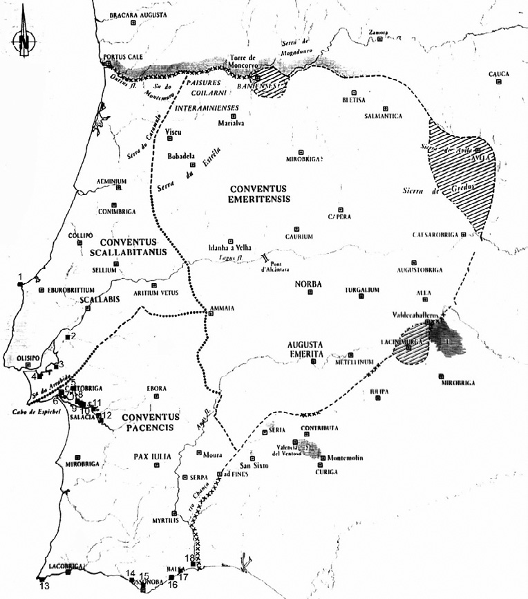
Figure 1 – Pottery centres: 1‑Morraçal da Ajuda; 2‑Garrocheira; 3‑Porto dos Cacos; 4‑Quinta do Rouxinol; 5‑Zambujalinho; 6‑Largo da Misericórdia; 7‑Quinta da Alegria; 8‑Pinheiro; 9‑Xarrosinha; 10‑Abul; 11‑Bugio; 12‑Barrosinha; 13‑Martinhal; 14‑Quinta do Lago; 15‑S. João da Venda; 16‑Torre de Aires; 17‑Manta Rota; 18‑S. Bartolomeu de Castro Marim. (Fabião 2004, 389)
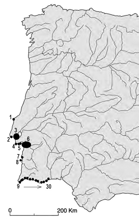
Figure 2 – Fish-salting workshops: 1‑Peniche (?); 2‑Cascais; 3‑Tagus estuary: Casa do Governador da Torre de Belém, Baixa de Lisboa, Porto Brandão and Cacilhas; Sado estuary: 4‑Creiro; 5‑Rasca; 6‑Comenda, Setubal and Tróia; 7‑Sines; 8‑Ilha do Pessegueiro; 9‑Beliche; 10‑Ilhéu da Baleeira (?); 11‑Salema; 12‑Boca do Rio; 13‑Burgau; 14‑Senhora da Luz; 15-Lagos and Meia Praia. 16 – Vau; 17 – Portimões; 18 – Baralha 2; 19 – Ferragudo; 20‑Armação de Pêra; 21‑Cerro da Vila; 22‑Quarteira; 23‑Loulé Velho; 24‑Quinta do Lago; 25‑Faro; 26‑Olhão; 27‑Quinta de Marim; 28‑Torre de Aires; 29‑Quinta do Muro and 30‑Cacela. (Fabião 2009b, 565)
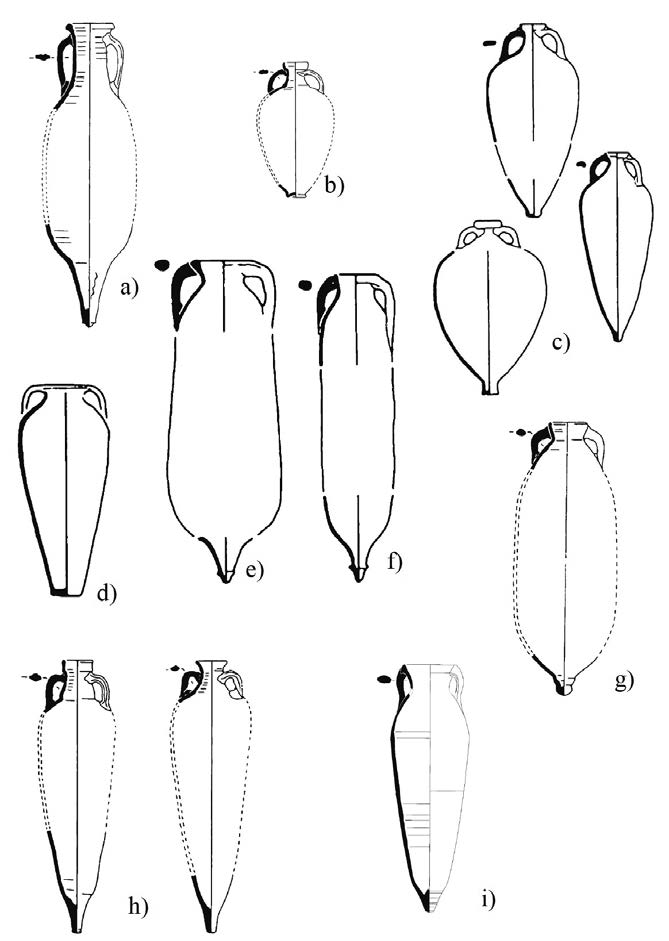
Figure 3 – Lusitanian amphorae types: a) Dressel 14, b) Lusitana 3, c) Almagro 51c, d) Lusitana 9, e) Keay XVI, f) Almagro 50, g) Keay 78/Sado 1, h) Almagro 51 A&B and i) Sado 3
The archaeological evidences, from mid-1st century BC, reveal a major utilisation of Spanish mackerel in the Baetican production (Desse- Berset and Desse 2000; García Vargas 2006, 41). On the other hand, fish bones of sardines have been found in several Lusitanian amphorae from shipwrecks (Fabião and Guerra 1993, 1005–1006; Desse-Berset and Desse 2000) (Table 1). In addition, sardine (Sardina pilchardus) was the principal component of the contents found in the tanks from Lusitanian factories: “Casa do Governador”, Rua dos Correeiros, “Mandarim Chinês”, factories I and II of Tróia, Quinta do Marim (Olhão) and Travessa do Freire Gaspar (Setúbal). All the analysed fish remains came from a later phase in the use of fish vats, between the 3rd and the 5th centuries (Desse-Berset and Desse 2000, Assis and Amaro 2006, Gabriel et al. 2009). Thus, it seems that, at least in Late Antiquity, sardine was a most important element in the manufacturing of fish products in Lusitania.
Nevertheless, the identification of processed fish remains is a complicated task, and there are still discrepancies between the archaeozoological evidence and the one provided by epigraphic and literary sources (Van Neer et al. 2010, 162).
As an event that occurs at a single point in time, the shipwreck presents a very narrow chronological spectrum. Isochrony is one of the main characteristics of the goods transported by a ship and found among a shipwrecked cargo (Blot, J.-Y. 1998, 118). It is an exceptional archaeological context. “Each underwater shipwreck site that has been excavated and published provides a snapshot of the trade of its time, as we may deduce that all objects being transported were contemporary; if not produced in the same year, they were at least sold at the same time” (Mayet 1998, 83).
Amphorae play an important role in the study of maritime trade, as they are containers specifically designed for maritime transport (Carreras Monfort 2000, 32). The importance of the amphorae found in the marine environment is linked to their context and conservation state. When conserved as a whole, which happens in many cases, it is possible to define their shape, size and capacity. They often preserve stamps and tituli picti that provide us with relevant information regarding origins, contents and trading processes. On the other hand, they allow us to infer navigation and maritime traffic routes that can be defined not only by the shipwreck location but also, and mainly, by the combination, in the same load, of archaeological materials of different origins. That is to say that, in some cases, the arrangement of different goods on board of a wrecked ship provides insight into the route of its final voyage, or the use of entrepôts (Parker 1992b, 89).
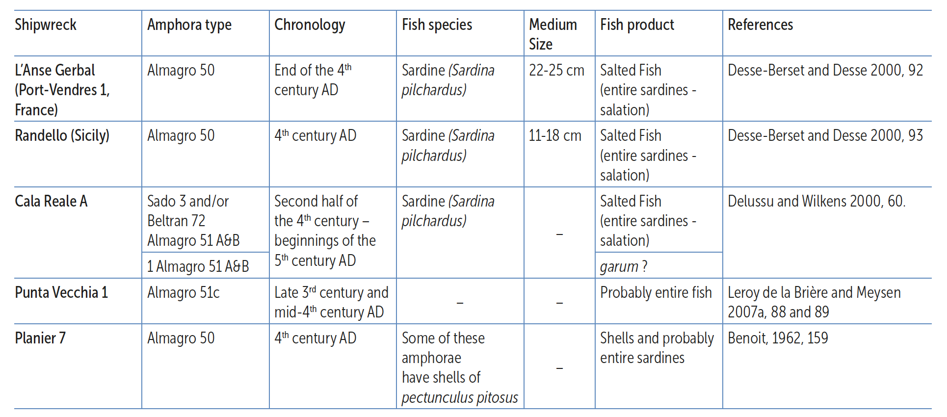
Table 1 – Faunal remains in Lusitanian amphorae
Note: In the shipwrecks of Catalans (Marseilles) and Sud-Lavezzi 1 have been identified remains of Spanish mackerel (Scomber japonicus) associated to the Almagro 51 A&B/Keay XIX amphora type, probably from a South-Hispanic fabric, non-Lusitanian.
The data included in this paper is part of a wider research project that is currently under way within the scope of the doctoral thesis of the author. The data presented here represents only a small sample of the data available for analysis, which corresponds to more than 40 shipwreck sites. Based on the published data (Edmonson 1987, Lopes and Mayet 1990, Parker 1992a, Étienne and Mayet 1993–94, Fabião 1996 and 1997), we are trying to update the inventory of shipwreck sites containing Lusitanian amphorae. In the late 1990s, Carlos Fabião presented an updated inventory with a total of 33 shipwreck sites that contained “Lusitanian type” amphorae (Fabião 1997), a much greater number of sites than the previous inventory from F. Mayet, which recorded 17 shipwrecks (Lopes and Mayet 1990, Étienne and Mayet 1993–94). More recently, Andrew Philip Souter, based solely on the above-mentioned published data, reintroduced a distribution of Mediterranean shipwrecks that contained Lusitanian amphorae (Souter 2012, 156). However, in the last 17 years, a set of new underwater archaeological works allowed for the adding of new shipwreck sites to the inventory (Bombico et al. 2014 and Bombico, in press).
For this paper, only a small number of sites have been selected. They seem to correspond to different models of commerce and transport that fall largely within the east-west routes departing from the Iberian Peninsula towards Rome. The global analysis of the available data suggests a much more complex set of routes that include the Central and Eastern Mediterranean, but we will not address this here.
Shipwrecks constitute a primary source for studies on the circulation of goods; however, they pose limitations. Shipwrecks have been described as closed deposits, and yet there may be elements of disturbance or contamination, especially in port contexts or ship graveyards, such as some sites in the Strait of Bonifacio. In some cases, mistaken topography and insufficient information about the material found or the site itself cause serious problems for the archaeological interpretation (Parker 1981, 332).
The set of shipwrecks traditionally associated with the presence of “Lusitanian type” amphorae is, overall, a set of ill-characterised underwater sites. Those are, for the most part, sites where occasional surface sampling (with poor location records and lacking scientific rigour) took place, where a systematic archaeological intervention has never been carried out, and where results have been published in an incomplete way. The big challenge here would be to clarify these data, which, ideally, would entail the re-examination of all the amphorae that have been identified in all of the shipwreck contexts. Such challenge, however, will not be totally met within the scope of the aforesaid doctoral thesis, mainly for reasons that have to do with the time available to perform the investigation, and the ample geographical dispersion of the finds, and of the collections. On the other hand, much of the material recovered during the 1960s, the 1970s and the 1980s cannot be located.
But perhaps the biggest problem in analysing these data is the recognition of Lusitanian fabrics. Their identification has proved problematic, mainly because of developments in the archaeological research of Hispanic pottery workshops. Today, we know that “Lusitanian type” amphorae (amongst which are the forms of wider distribution Dressel 14, and the Almagro 50 and 51 series) were also produced in other parts of southern Hispania (Bernal Casasola 1998, Bernal and García Vargas 2008, Fabião 2008). In order to clarify their origin it is necessary to reassess, in the light of the new data, the ceramic assemblages that were published in particular up until the 1990s and the inventories held in museums. On the other hand, it remains difficult to identify Lusitanian productions amongst the vast set of published data, as it is very common to find generic classifications of origin, such as “South-Hispanic” or simply “from the Iberian Peninsula”.
It should also be taken into account that fish products were, in some cases, a secondary cargo that could have been part of a subsidiary and free trade system whose volumes did not come close to the ones of the redistribution of wheat, olive oil, wine, metals or marble, promoted by the state, and bound for the two great markets of the Roman world: Rome and the military camps (Tchernia 2011). In addition, the underwater archaeology data have emphasised the presumed complementary role of the diffusion of Lusitanian productions in relation to other regions, namely Baetica (Mantas 1990, 170 and 191; Lopes and Mayet 1990, 299 and 300).
The set of shipwrecks with amphorae of Lusitanian production on board is quite heterogeneous. There are cases in which Lusitanian amphorae constitute the main cargo and cases in which they are secondary or supplementary cargo. There are also some examples in which their small quantity seems to indicate that they would have been part of the crew’s belongings. However, in any case, their presence allows us to establish chronologies and understand routes (direct, redistribution, long distance, cabotage, etc.). And in some cases, the remains of the hull may indicate the size and capacity of the vessel.
The heterogeneity of the shipwrecks allowed us to conjecture a few different models of circulation and transportation. We have sought to build a comprehensive image of the diversity of existing cases over, i.e., from the middle of the 1st century AD to the end of the 5th century AD. Similarly to what has been recently done by Giulia Boetto (2012, 156), we have selected a heterogeneous sample of wrecks and applied hypothetical models of “commercial routes” to them (Figure 4).
The transportation of Lusitanian fish products must have occurred by way of a homogenous shipment that is loaded at the same time in a major port – located near the area of production of the cargo – and then sent through a direct route to another major port. This model is likely to have been used for transport between, for example, the port of Olisipo and Gades or Olisipo and Carthago Nova, and less likely to have been used in very long distance routes, such as the ones between Olisipo and Rome, although the shipwreck of Cala Reale A, in northern Sardinia, with a predominantly Lusitanian cargo, may suggest such model. Yet, it is very likely that a significant part of Lusitanian fish products may have been exported via negotiatores based in the port of Gades (Lopes and Mayet 1990, 300; Étienne and Mayet 1993–94, 216; Mantas 1998, 208 and 213).
Figure 4 – Shipwrecks containing Lusitanian amphorae and discussed in the text:
1st/2nd century: 1‑San Antonio Abad; 2‑Cap Bénat 1; 3‑Punta Sardegna A; 4‑Escombreras 4; 5‑Tiboulen-de-Maire
3rd century: 6-Cabrera I; 7-Cabrera III; 8-Punta Ala A; 9-Porticcio A
4th/5th century: 10-Cala Reale A; 11-Sud-Lavezzi 1; 12-Fontanamare A/Gonnesa Sito A; 13-Punta Vecchia 1; 14-Sancti Petri; 15-Scauri
Therefore, we believe that shipwrecks with predominantly Lusitanian cargos can correspond to a model which is somewhat different from the one previously described and would originate from a South-Hispanic port, such as Gades or Carthago Nova – i.e., a homogenous shipment that is loaded at the same time in a major port – far away from the area of production of the majority of the goods – and sent through a direct route to another major port. The wrecks of San Antonio Abad/Grum de Sal (Ibiza), Cap Bénat 1 (Var, France) or Punta Sardegna A (Strait of Bonifacio), all with a homogeneous main cargo of Lusitanian Dressel 14 amphorae, which are datable from the second half of the 1st century to the middle of the 2nd century AD, fit into this type of route parting from the south of the Iberian Peninsula and heading to one of the larger ports of the south of Gaul or to the ports of Rome.
In the summers of 1962 and 1963, archaeological campaigns were carried out at the shipwreck site of San Antonio Abad (Ibiza). Several amphorae belonging to the Dressel 14 type (Figure 5), containing a fish-based product, were retrieved, as well as some opercula (Vilar-Sancho and Mañá 1964 and 1965), the remains corresponding to a vessel with no less than 25 meters in length (Vilar Sancho and Mañá 1964, 187). Later, during the 1980s and 1990s, the site was again subject to archaeological works, and the ceramic materials were stored in the deposit of the Museo Arqueológico de Ibiza y Formentera.
The shipwreck site known as Cap Bénat 1 had its first intervention in 1971. With the exception of two different fragments, a flat-bottomed amphora and a PE 25 from Ibiza, the total of the materials observed and retrieved belonged to the same amphora type. The formal description and the drawings allow us to identify the amphorae as being Dressel 14 (Figure 6), and the description of the fabric indicates a probable Lusitanian production (Calmes 1973, 142). There were also three opercula retrieved (Calmes 1973, 137–140). The majority of the retrieved pieces are presently in the Dépôt de Saint-Raphael (Fréjus); however, we were able to examine a rim fragment and a spike of Dressel 14 of Lusitanian fabric in the Depôt archéologique régional d’Aix les Milles.
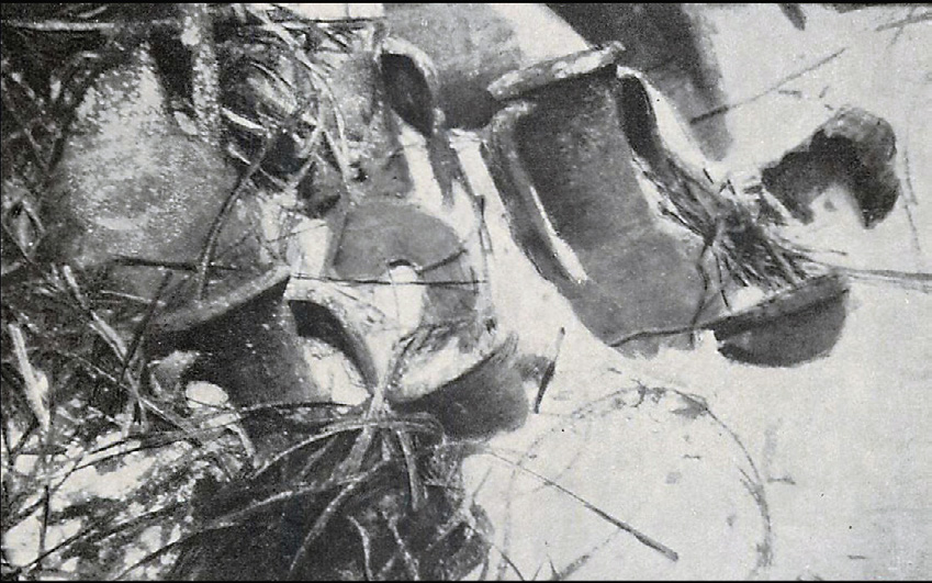
Figure 5 – Dressel 14 amphorae from San Antonio Abad shipwreck. (Vilar Sancho and Mañá 1965, Lamina XLVII)
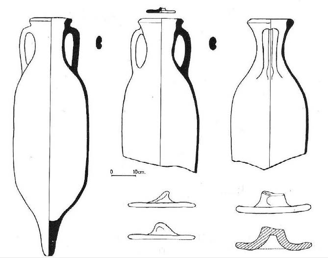
Figure 6 – Dressel 14 amphorae and opercula from Cap Bénat 1 shipwreck. (Calmes 1973, 143)
The site of Punta Sardegna A is located in the Maddalena Archipelago, in the southern part of the Strait of Bonifacio. This place has recently undergone underwater archaeological works carried out by the Università di Sassari, under the supervision of professor Pier Giorgio Spanu. Based on the work performed on the site, we can assume that the shipwreck was a vessel carrying mostly Lusitanian amphorae of fish products from the Dressel 14 type. But also a spike of Dressel 7-11, a handle of Dressel 20 from Baetica, a spike of Dressel 2-4 Italic and two opercula were recovered from the site (Porqueddu 2013, 86–90, 114–115; Porqueddu, Giarrusso and Spanu, in press).
Until the mid-2nd century AD, archaeological records also present cases in which Lusitanian Dressel 14 amphorae were a secondary cargo, a residual cargo, or simply objects that belonged to the crew. We have chosen two examples: Escombreras 4 and Tiboulen-de-Maire.
The site of Escombreras 4 is located on the coast of Carthago Nova. It is presumed to be the shipwreck of a merchant ship coming from Baetica with a main cargo of Haltern 70, Dressel 8 and 9, and some Beltrán IIB and Lusitanian Dressel 14, from the second half of the 1st century AD (Pinedo Reyes and Alonso Campoy 2004, 131–133). A specimen of these amphorae, which we were able to observe, is deposited in the MNAS (Arqua-Cartagena) (ESC-I/17.17/2/10354).
The site of Tiboulen-de-Maire is located near a small island, to the south of Marseille. The site has undergone two underwater archaeological campaigns carried out by DRASSM (Département des recherches archéologiques subaquatiques et sous-marines) in 1977 and 1978. Since 1999, survey and excavations have been undertaken yearly at the site. It is a presumed shipwreck with a main cargo of Baetic olive oil amphorae Dressel 20 (70%), and a heterogeneous secondary cargo including: fish sauce amphorae types Beltrán IIA and IIB (14%), and Dressel 14 (2%); wine containers Gauloise 4 (4%), Dressel 28 (3%) and Dressel 2-4 from Tarraconensis (3%), two Forlimpopoli amphorae; a North African amphora and a Dressel 7-11 (Djaoui 2011, 625). The cargo materials establish a chronology between AD 130 and AD 150, and the archaeological works of the last decade allowed for the study of the remains of the hull (Ximénès and Moerman 2006). More recent campaigns, undertaken mostly after 2005, have confirmed that more than 80% of the transported goods were from Baetica, particularly olive oil. We can assume that there was a home port located in that region, with a hypothetical use of a redistribution port, such as Narbonne or Marseille (Ximénès 2007, 10; Djaoui 2011, 629). At the Dépôt archéologique régional d’Aix les Milles there is a top part of a Dressel 14 of Lusitanian fabric, retrieved from this shipwreck.
The two following cases outline the maritime exports of Lusitanian fish products throughout the 3rd century AD. These were shipments of different product ranges, loaded at the same time at a main redistributing port and most likely headed for another main port. Lusitanian amphorae shared cargo space on board of the ships with Baetican and North African containers. This presents a peculiar scenario, since, within this chronology, there are no shipwrecks in which Lusitanian amphorae were the main cargo. This may be connected to the above mentioned period of transition, documented through the levels of archaeological finds related to the fish processing factories and amphora kilns in Lusitania.
The shipwreck of Cabrera I was surveyed between 1978 and 1979 and is located at about 60 meters from Cabrera III. According to records from the time of the survey, it was possible to identify several amphorae of types Almagro 50 and 51C, Béltran 72, and Africana II variants B and D. This cargo is identical to the one of Cabrera III, which dates the shipwreck to AD 300–325 (Guerrero Ayuso and Colls 1982; Bost et al. 1992, 13; Parker 1992a, 80).
The site of Cabrera III was also surveyed in 1979, having been later excavated in 1985 and 1986. The shipwreck was dated to the year AD 257, based on the treasure of coins aboard the ship. According to naval architecture data, this was a ship of about 35 meters in length. The cargo was stacked in two layers and was composed of Baetic olive oil amphorae Dressel 20 and Tejarillo I, Africana II variants B and C, Almagro 50 and 51C from Lusitania and a small number of Beltrán 68 and Beltrán 72. The cargo also included ARS types A and C (Guerrero Ayuso and Colls 1982; Bost et al. 1992; Parker 1992a, 81). The specimens from the types Almagro 50 and 51c, exhibited in the Museo de Cabrera, have Lusitanian fabrics.
The archaeological works carried out at these sites led to the conclusion that, on the basis of the disposition of the containers, all had been shipped at the same time. So, considering the apparent Iberian provenience of much of the cargo and the location of the wreck in the Balearic Islands, it seems that the ship was in route from the Iberian Peninsula to Italy, with Gades as its most probable port of departure, and Ostia/ Portus as its likely destination (Bost et al. 1992, 200–202).
The 3rd century reveals yet another interesting shipwreck context: the site of Porticcio A, located on the west coast of Corsica. This shipwreck contains a very heterogeneous cargo, probably loaded at the same time at a main redistributing port and transported along a redistribution route to a secondary port. The location of the shipwreck and the characteristics of its cargo suggest that this was a cargo that had been ordered. The site was discovered in 1990 and was subjected to archaeological works from 2001 onwards. The quite heterogeneous cargo includes amphorae form the eastern and western Mediterranean, ARS type C, common ware and African cooking ware, some mortaria, one lamp, over 100 glass objects and several fragments of marble statues (Alfonsi 2008a and 2010). The shipment of amphorae is mostly Kapitan II, with a smaller amount of Africana II and Kapitan I. The great variety of amphorae types also includes a smaller presence of the following types: Africana I, Forlimpopoli, Agora M254, Almagro 51C, Almagro 50, Dressel 20, Dressel 23, Agora F65/66, Crétoise 2, Dressel 30, Dressel 28, Beltrán 72, Amphore Égyptienne, Empoli, Tripolitana, Peacock & Williams 60 and Zemer 57, besides other unclassified types. The re-examination of the materials of the deposit of Sartène confirmed the presence of three rims and of a spike of Almagro 51C of Lusitanian fabric. Amongst the marble pieces, fragments belonging to two monumental statues stand out: a bust representing the Emperor Philip the Arab, who reigned between AD 244 and AD 249, and another one likely belonging to his wife, Empress Marcia Otacilia Severa (Alfonsi 2007, 93; 2008a and 2008b). Remains of the hull of the ship were also identified (Alfonsi 2003, 79 and 2006, 94). The two coins that were discovered, one from Philip I and another from Philip II, provide a terminus post quem of AD 248–9 for the shipwreck (Alfonsi 2006, 91). In this specific case, the Lusitanian amphorae are residual in a very heterogeneous cargo. Considering the description of the cargo, the most likely origin of this vessel was the port of Carthage. Michel Bonifay (2007, 257) compares this shipwreck to the one of Ognina Sud 1, dating to the first half of the 3rd century, in which a shipment of eastern Kapitan I and II amphorae completes a shipment of mostly Africana I. According to the author, these two shipwrecks suggest that the joint commercialisation of African and eastern types could have been done from the North African ports.
During Late Antiquity, the number of shipwrecks containing Lusitanian amphorae is quite larger. This supports the archaeological data from Lusitania, which reveal a considerable increase in the production of fish products throughout the 4th century, and at the outset of the 5th century (Fabião 2009b, 571). Between the end of the 3rd century and the beginning of the 5th century, a quite varied set of shipwrecks sustains the evidence of distinct cargo typologies and of different circulation scenarios, likely contemporaneous. However, the main commerce routes that led from southern Baetica to Ostia and Portus via coastal Tarraconensis and southern Narbonensis were generally kept, as were the variants that used a process of island hopping (Balearic Islands, Corsica and Sardinia) on routes that led towards Italy via the Strait of Bonifacio.
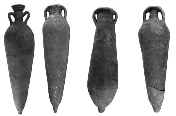
Figure 7 – Amphorae from Cala Reale A shipwreck. From the left to the right: Almagro 51&B, Sado 3, Beltrán 72 and Almagro 51C (Gasperetti 2012, fig.8)
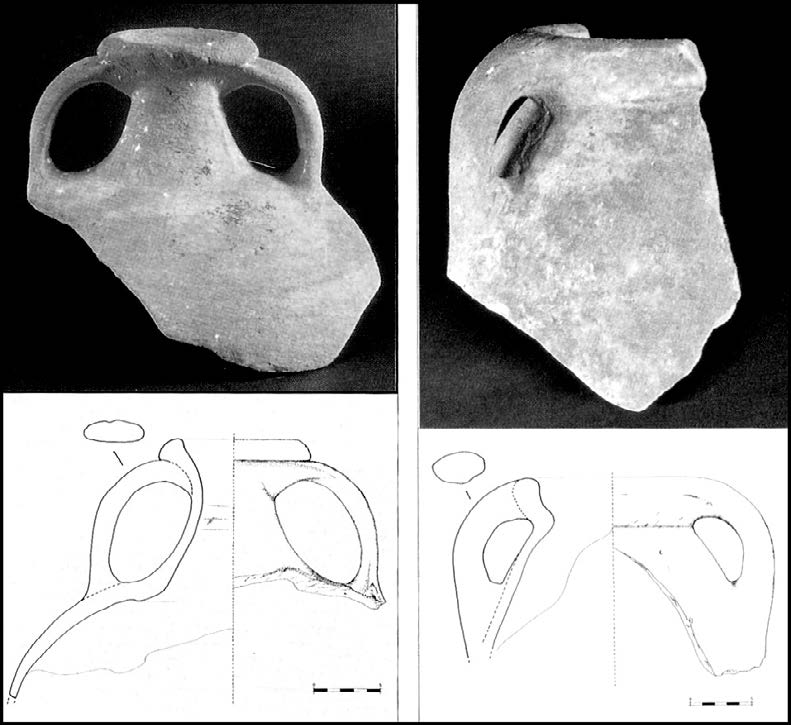
Figure 8 – Amphorae from Fontanamare A shipwreck: Almagro 51C and Keay 78 (Dell’Amico et al. 2001-2002)
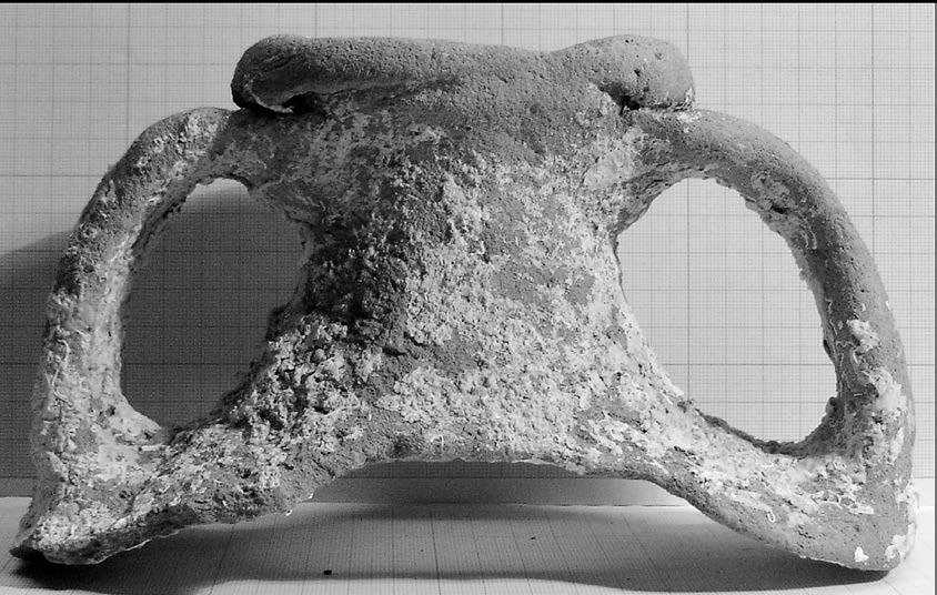
Figure 9 – Almagro 51C from Punta Vecchia 1 shipwreck. Photo: Sónia Bombico
We will analyse three distinct types of cargo. Firstly, the Cala Reale A shipwreck (Strait of Bonifacio), in which the Lusitanian amphorae were, apparently, a homogeneous main cargo. (Figure 7). After its discovery, in 1995, the site has undergone various underwater archaeological campaigns. From what was published, we are able to confirm the existence of amphorae belonging to types Almagro 51 A&B, Almagro 51C, Beltrán 72 and Sado 3 (Spanu 1997, 111 and 112). Some of the amphorae still contained in situ their original cork stoppers and also some traces of fish-based products (Spanu 1997, 112). In addition to the amphorae, the archaeological works allowed for the recovery of two North African lamps, of African cooking ware, of a pitcher, of a considerable number of vitreous paste tessellae, and of two coins, one dated from the year 173 and one from the reign of the Emperor Valens (364–7). The set of materials that were retrieved allows us to establish a chronology for the shipwreck between the late 4th century and the middle of the 5th century. The total quantification revealed a cargo of around 2,000 amphorae. No remains of the vessel were identified during the whole excavation process. This vessel was likely bound for the port of Ostia and sank while approaching Turris Libisonis, possibly due to stormy weather or to touching bottom in rocky shoals (Gasperetti 2012, 301–303). During our visit to the Antiquarium Turritano and to the Centro di restauro e conservazione dei beni culturali di Sassari we were able to confirm that the totality of the above-mentioned forms was of Lusitanian origin.
Also located on the Strait of Bonifacio, the shipwreck of Sud-Lavezzi 1, discovered in 1975, suggests a model in which the Lusitanian amphorae are the main cargo, along with other Hispanic products – Baetican in this case. Parts of the remains of the hull and some iron anchors were still preserved. The cargo, estimated at 450 amphorae, was arranged in two overlapping layers. Liou (1982, 437–444) studied this cargo, comprised of: 194 Almagro 51 A&B amphorae of varied profiles and capacities; 113 flat-bottomed amphorae of different sizes; 83 cylinder-shaped body amphorae from type Almagro 50 [or Keay 78]; some small amphorae of type Beltrán 72; 6 Almagro 51C and 3 Dressel 23. The splitting of the finds between the company Comex and the DRASSM resulted in the loss of some of the assets, aggravated later by the theft of the materials stored in the DRASSM deposit in Bonifacio. Liou suggests a time frame for the shipwreck somewhere between the 4th century and the middle of the 5th century (Massy 2013, 132–134). A small number of pieces are presently stored in the deposits of Milles and Sartène, allowing us to re-examine 13 specimens. We were able to identify the following Lusitanian fabrics: 3 Beltrán 72, 3 Almagro 51 A&B, and 2 Keay 78.
The third model corresponds to a main cargo of Lusitanian fish products with North African products, Africana II variants B and D, and ARS types C and D. Two examples will be highlighted.
The site of Fontanamare A/Gonnesa Sito A was excavated for the first time in 1972; however, the material that was retrieved remained unpublished until the late 1990s (Dell’Amico et al. 2001–2002). Three types of amphorae were documented on this site: Almagro 51C (the most abundant), Almagro 50 and/or Keay 78 (Figure 8) and Africana II variant D. Between 1997 and 1999, survey work took place on the site (Salvi and Sanna 2000). At least one third of the cargo appears to have been ARS, in this case the more typical forms of type C (second half of the 3rd century) and the more ancient forms of type D (beginnings of the 4th century AD). This site also revealed another set of interesting archaeological remains, among them: two amphorae cork stoppers; two lamp fragments and some common ware, probably belonging to the crew; tubuli and tegulae; metal pieces; and also some remains of the ship itself. Lastly, it is also worth mentioning that an important set of coins was found, with a chronological scope from AD 260 (Gallienus) to AD 294 (Maximianus), thus establishing the terminus post quem of the shipwreck (Dell’Amico et al. 2001–2002, 23, 45, 46, 52, 71, 83, 86, 87 and 127). The joint analysis of the recovered materials indicates that the shipwreck occurred within the first few decades of the 4th century AD.
Dell’Amico and Pallarés suggest several hypotheses regarding the port where the ship that sank at Fontanamare was loaded. The first one presents the possibility that the loading took place in one of the redistribution ports on the southern coast of Spain. These were ports to which North African products converged via the so called “Phoenician Route”, a route that moved from east to west along the North African coast (Dell’Amico et al. 2001–2002, 142). This hypothetical scenario is similar to the one suggested for the shipwreck of Cabrera III (Bost et al. 1992, 200 and 201). Another hypothesis is that Carthage was the ship’s port of origin (Dell’Amico et al. 2001–2002, 144). In this case, the ship would have been moving in the opposite direction, meaning that Lusitanian products were being brought into the port of Carthage through routes established along the North African coast.
From the site of Punta Vecchia 1 (Cap Corse), numerous amphorae fragments were recovered between 2004 and 2007, amounting to a total of 65 pieces. Amphora tops (rims, necks and handles) and spikes of Almagro 51C of two different sizes (67%) (Figure 9), one handle that could be of the Keay 78 form, possibly a spike of Almagro 51 A&B, another possible spike of Beltrán 72, and fragments of amphorae of Africana II, variants D and B (17%). The materials that were recovered point to the shipwreck having occurred between the late 3rd century and mid-4th century AD, with a predominately Lusitanian cargo. Small remains of wood were also identified during the works (Leroy de La Brière and Meysen 2004; Leroy de La Brière 2006, 87; Leroy de La Brière and Meysen 2007a, 88 and 89; Leroy de La Brière 2007b and Massy 2013, 110–114). The re-examination of the materials, performed in November of 2013 at the Depôt de Bastia (DRASSM), confirmed that the totality of the fragments of Almagro 51C were of Lusitanian fabric.
This shipwreck, along with the Punta Ala A one (Dell’Amico and Pallarés 2006), confirms the circulation of Lusitanian amphorae on the circuits of the Tyrrhenian Sea and of the Ligurian Sea. Travelling along this route, ships would leave Rome, frequently with return cargos or cargos for redistribution, and when reaching the Strait of Bonifacio, would head north along the coast of Tuscany. Sailing through the Strait of Bonifacio from east to west was hindered significantly by the winds blowing from the west, so that travelling between Ostia and Gallia was done mostly through Cap Corse (Arnaud 2005, 165). A set of underwater archaeological data also documents that ships sailed in the opposite direction, along the northern coast of Corsica and of Cap Corse. This suggests an alternative route for the passing of the Strait of Bonifacio, not only for the vessels coming from Gallia, but also from the Iberian Peninsula (Arnaud 2012, 136–138). This might have been the case of the ship sunk in Punta Vecchia 1.
The continued export of Lusitanian fish products during the 5th century, already substantiated by the Cala Reale A shipwreck, is also reliably documented in two other contexts: Sancti Petri (Bay of Cadiz) and Scauri (Island of Pantelleria) (Alonso Villalobos et al. 1994, Baldassari 2009a and 2009b). In spite of the evidence – revealed by these two sites – regarding the continuity of the exports of Lusitanian salting fish preparations during the 5th century, underwater archaeology has not yet been able to provide direct proof of its circulation after the fall of the Western Roman Empire.
The shipwreck sites used to illustrate the different scenarios of the circulation of Lusitanian amphorae allow us to develop some hypotheses regarding navigation routes. Using as reference the work of Pascal Arnaud (2005) – Les routes de la navegation antique, Itinéraires en Mediterranée – a work that contains, in our opinion, all of the relevant information gathered in the last decades, added to by the analysis of the works of Antiquity geographers such as Strabo and Pliny, we can now present the major sailing routes departing from the Iberian Peninsula with courses set for the ports of Rome (Figure 10).
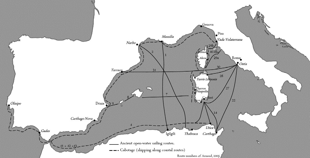
Figure 10 – Ancient sailing routes.
The shipwreck sites selected and described in this paper depict the circulation of Lusitanian fish products throughout the main navigation routes along the Western Mediterranean. As we pointed out, the transportation models are highly diversified, being perfectly adjusted to the major tendencies in trade and to the economic transformations that, throughout the years, took place within the Roman Empire. Between the early part of the 1st century and mid-2nd century AD, Lusitanian amphorae mostly circulated alongside Hispanic food products from Baetica and Tarraconensis, namely olive oil (Dressel 20), wine (Dressel 2-4, Haltern 70 and Dressel 28), fish sauce (Dressel 7-11, Beltrán IIA and IIB, Dressel 14A and 17), as well as ingots of lead or copper. From mid-3rd century AD, it becomes quite frequent for Lusitanian amphorae to be found alongside with North African products, transported in Africana II amphorae, variants B, C and D, used for the transportation of various fish goods (Bonifay 2004). This is further supported by their discovery on the Cabrera III shipwreck where fish remains were still visible (Slim et al. 2007, 40). This reflects the economic changes that, during the Late Antiquity period (Rice 2011, 85), transformed the African provinces into the great suppliers of food products destined for Rome. Shipwrecks, such as Cabrera III, may be considered as the logical outcome of the institutionally established supply chain to the Empire’s capital, based mostly on olive oil. The Lusitanian salted fish preparations were therefore an additional cargo, stored in the vacant space on board of the ships, thus allowing for the establishment of a free trade. Nevertheless, as we demonstrated, a wide set of alternative scenarios may have to be considered, especially regarding the Late Antiquity period.
Shipwrecks are only some of the pieces of the complex puzzle that is the distribution process of Lusitanian amphorae throughout the Mediterranean. Recreating a global scenario is a difficult task and will necessarily have to include the archaeological data from land contexts of the main maritime cities, coastal enclaves, ports and mooring places. In so far as this research is concerned, it has revealed the presence of Lusitanian amphorae in numerous archaeological contexts throughout the Western Mediterranean (Bombico et al. 2014 and Bombico, in press).
Customer Care
O CAN THE CAN utiliza cookies para lhe proporcionar uma melhor experiência online. Ao continuar a sua visita ao nosso site, concorda com a utilização de cookies.
Contact
reservations@canthecan.net
info@canthecan.net
T. +351 914 007 100
T. +351 218 851 392
Terreiro do Paço 82/83
1100-148 Lisboa – Portugal
Open everyday from 9:00 AM to 1:00 AM